
Vertel uw vrienden over dit artikel:
Rand McNally Folded Map: Tampa-St. Petersburg-Ocala to Sarasota Regional Map
Rand McNally
Besteld in een afgelegen magazijn
Onze klanten zeggen:

Rand McNally Folded Map: Tampa-St. Petersburg-Ocala to Sarasota Regional Map
Rand McNally
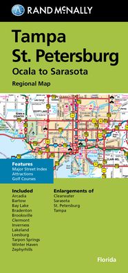
Rand McNally's folded map for Tampa St. Petersburg is a must-have for anyone traveling in and around this part of Florida, offering unbeatable accuracy and reliability at a great price. Our trusted cartography shows all Interstate, U. S., state, and county highways, along with clearly indicated parks, points of interest, airports, county boundaries, and streets. The easy-to-use legend and detailed index make for quick and easy location of destinations. You'll see why Rand McNally folded maps have been the trusted standard for years. -Regularly updated. -Full-color maps. -Clearly labeled Interstate, U. S., state, and county highways. -Indications of parks, points of interest, airports, county boundaries, downtown & vicinity maps. -Major attractions & Golf Courses. -Enlargements of Clearwater, Sarasota, St. Petersburg & Tampa. -Easy-to-use legend. -Detailed index & Major Street Index. -Convenient folded size. Coverage Area: Communities included, Arcadia, Bartow, Bay Lake, Bradenton, Brooksville, Clermont, Inverness, Lakeland, Leesburg, Tarpon Springs, Winter Haven, Zephyrhills. Product Details: Measures 9.5' x 4' and folds out to 40' x 28'.
| Media | Boeken Map (Land- of zeekaarten) |
| Vrijgegeven | 22 september 2021 |
| ISBN13 | 9780528025488 |
| Uitgevers | Rand McNally |
| Afmetingen | 106 × 226 × 12 mm · 77 g |
| Taal en grammatica | Engels |
Meer door Rand McNally


Anderen hebben ook gekocht
![Cover for Preben Hansen · Turen Går Til: Turen går til Californien & Vestlige USA (Sewn Spine Book) [5e uitgave] (2021)](https://imusic.b-cdn.net/images/item/original/578/9788740063578.jpg?preben-hansen-2021-turen-gaar-til-turen-gaar-til-californien-vestlige-usa-sewn-spine-book&class=scaled&v=1623395637)
![Cover for Knud Romer · Den som blinker er bange for døden (Sewn Spine Book) [5e uitgave] (2016)](https://imusic.b-cdn.net/images/item/original/573/9788711569573.jpg?knud-romer-2016-den-som-blinker-er-bange-for-doeden-sewn-spine-book&class=scaled&v=1480182943)
![Cover for Kerstin Ekman · Ulvespring (Bound Book) [1e uitgave] (2022)](https://imusic.b-cdn.net/images/item/original/272/9788702347272.jpg?kerstin-ekman-2022-ulvespring-bound-book&class=scaled&v=1661970721)
![Cover for Jens Andersen · Kongeord (Bound Book) [1e uitgave] (2024)](https://imusic.b-cdn.net/images/item/original/776/9788740092776.jpg?jens-andersen-2024-kongeord-bound-book&class=scaled&v=1706260512)


Bekijk alles van Rand McNally ( bijv. Paperback Book , Map , Hardcover Book , Book en Spiral Book )